(Last updated on 13/10/2025)
Ruta de la Sierra is a walking route in Serradilla, a village located in the Monfragüe and surroundings area of Cáceres province, featuring a viewing platform and several picnic areas with a view along the ridge of Sierra de Santa Catalina.
This article includes a general overview of the route, practical details, my personal thoughts and tips to help you plan and make the most of the walk.

This post contains affiliate links. If you click through and make a purchase, it will generate a small commission for me, at no extra cost for you. Read the full disclosure for more details.
Overview
Ruta de la Sierra is a 6.3km long, circular (not FEXME-approved) route that takes just over two hours to complete. It starts and finishes at the main square in Serradilla.
The main highlights of the route are the newly-installed Canchu del Lobu viewing platform, the different terrains and plant species (with a strong presence of arbutus unedo), the panoramic views along the ridge of the sierra, a nineteenth-century fountain and a convent.
Note that from the start point, you’re meant to walk up Calle Navas de Tolosa and complete the route clockwise, but I walked anticlockwise. This article is about the (anticlockwise) Ruta de la Sierra that I completed.
Start: Plaza de la Constitución
Finish: Plaza de la Constitución
Length: 6.3km
Time: 2h 5min (without stops)
Difficulty: medium (3/5)
Cumulative elevation gain: 210m
Ruta de la Sierra on a map
My thoughts on this route
I walked Ruta de la Sierra in late November, on a rather bright day of light cloud, starting off at 12:15pm. The fairly steep climb up to the viewing platform made me warm up quickly. I had to take off my fleece jumper pretty soon and wear a long-sleeve thermal baselayer only. But the fleece came in handy later on when I stopped near the viewing platform for a quick lunch, as it got chilly near the ridgetop.
The route starts at the main square and follows the much longer, FEXME-approved Camino Natural del Tajo GR 113 route until reaching the viewing platform. Facing the townhall (Ayuntamiento), take the street on your right (Calle de la Plaza), walk past the Santuario Santísimo Cristo de la Victoria along Calle Liberato Alonso, and turn left to Finca Taheña Fuente Apio; then turn right and follow the signs for Fuente Nueva – a large semi spheric fountain built in slate and brick in 1894, not in use anymore.


The route panel you’ll see at the corner of Paseo de Extremadura with Avenida San Antonio marks Ruta de la Sierra in pink, but bear in mind that the sign posts along the way for this route are actually violet.
Leave Fuente Nueva on your right. A concrete path soon gives way to a steep, unpaved, stone-strewn path. Vegetation is rather rich, featuring mainly shrubs at first, and a mix of shrubs and trees further up.


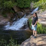
I found this first part of the walk more tiring than I had anticipated, but the views from the Canchu del Lobu viewing platform are well worth the effort. This mirador was recently installed in Camino de Najarro, where several different walking routes converge. Next to it, a metal sculpture of a wolf (a local symbol) sits atop a large rock. The southern views of Serradilla and the surroundings at this time of the year were splendid. Since we reached this point in the middle of the day, it was too bright to properly capture the view on pictures, the third one below not really doing justice to the view.


After stopping for half an hour for lunch, we continued our walk, taking the path furthest to the left on the bend. Pine trees suddenly abound, and so do arbutus unedo (also called ‘strawberry trees’). This path, gently climbing to the ridgetop, is a lot easier to walk on.


In the second part of the route, the path follows the ridge of Sierra de Santa Catalina, past several viewpoints. The first two are situated to the left and to the right, respectively, of a little building atop a large granitic rock, and offer a great 180-degree southern view. Despite there not being any viewpoint looking north, it’s worth looking for a spot on your right, near the path, to enjoy the northern views, too.


The remaining stretch of path along the ridge is very exposed to the elements, with trees lining up only on the right side. The weather was mild when I completed this route, but it did get breezy and even a bit chilly up here.

The next good place for a quick stop is a picnic area next to a little chapel known as La Casetina. But you can enjoy a probably even better southern view from this viewpoint, situated just a bit further on, near the point where the path stops being lined with trees.


The last part of the route involves a steep descent to the village on a mostly ankle-breaking path that seems to have been loosely carved into the rock, with several stretches of more comfortable terrain in between. It then joins a paved, single-track road to the centre of Serradilla, past a small, whitewashed chapel.


Don’t miss: (1) the impressive mural at the corner of Calle Navas de Tolosa and Calle Cerro; and (2) the metal words in the local Serradilla dialect displayed at the front of numerous houses along the way.


Tips and practical info
When to do this route: Ruta de la Sierra is recommended for late autumn, winter (when not raining), and spring. Not suitable for the summer months (mid-June to mid-September).
Before/after the walk: you can combine a morning walk in Serradilla with another (perhaps short) afternoon walk in Monfragüe National Park, or with a boat tour on river Tagus.
Where to park: my general approach when visiting villages is to find on-street parking on a main road, or on a wide road outside the centre. In Serradilla, I parked on Paseo de Extremadura, near the corner with Avenida San Antonio and under five minutes on foot from the main square.
Where to stay: if you need a place to stay after completing this route, look for accommodation in Extremadura to find the most suitable place for your trip.
For more walking inspiration, read my thoughts on completing other walking routes in Extremadura.
This content is protected by copyright and belongs exclusively to Irene Corchado Resmella. To know exactly what this means, read the 'Copyright' section in the Website terms of use.
Irene Corchado Resmella
Hi! I’m Irene (/ee-REH-neh/). Long since settled in the UK, I explore my Spanish home region of Extremadura with an inquisitive mind, a sharp eye, and the duality that comes with being both a local and a visitor. Then I write about it here to help you discover this beautiful yet overlooked part of Spain. If you have any questions after reading this article, submit a comment below! Read more about me.