(Last updated on 13/10/2025)
Ruta Sierra de Alor is a walking route in the namesake mountain range located in western Badajoz province. This route makes for a great half-day trip from Olivenza since the start point is barely an eight-minute drive away.
In this article, I share a general overview of Ruta Sierra de Alor along with some practical info, and personal thoughts and tips to help you plan your walk.

Overview
This three-hour route starts outside the outlying village of San Jorge de Alor (belonging to the municipality of Olivenza). The route details available differ a little bit depending on the source you check:
According to Turismo de Olivenza, the route is 10.5 kilometres long, the start point is some 500 metres away from San Jorge de Alor, and the cumulative elevation gain is 286 metres.
According to REDEX, the route is 12 kilometres long, and the cumulative elevation gain is 286 metres.
According to the sign located near the start point, the route is 12 kilometres long, the start point is 300 metres away from San Jorge de Alor, and the cumulative elevation gain is 300 metres.

As I’ll explain below, we only walked part of this route, so this article only partially covers the official route.
Start: lat. 38.648186, long. -7.062111
Finish: lat. 38.621851, long. -7.065437
Length: ≈8km
Time: 2h
Difficulty: medium (2-3/5)
Ruta Sierra de Alor on a map
(Please note that I manually drew the route and it’s meant for rough reference only.)
My thoughts on walking Ruta Sierra de Alor
I did (part of) this route in mid-December and we could not have asked for better weather. It was a bright and sunny day of blue skies and 14 degrees Celsius just after 3pm.
It was the first day of a road trip around Badajoz province. After flying into Lisbon the previous evening, we drove straight across to Spain, arriving in Olivenza quite late. I did not have the best of sleeps that night and we spent the following morning walking and visiting the sights in Olivenza. By the time we started the walking route, we were already tired.
The first part of the route is nice and easy, following a track on flat terrain flanked by sheep-grazing olive groves.


Tip: Bear in mind that you’ll be walking south facing the sun for quite a while, so make sure you wear a cap, because the track is really exposed and shade is pretty much nonexistent.
I knew we were not going to make it to the end of the official route soon after the track started climbing. We decided then and there that our goal was going to be reaching the viewpoint (mirador panorámico) and complete about two thirds of the route.
The vegetation becomes denser as you climb, with olive trees giving way to cork oaks, which provide some well-needed shade. Then you arrive at a gate.


We passed through the gate and followed the path bearing left, which continued to ascend and led us to a picnic area past some stone shepherd’s huts. We sat at the picnic table and spent a good hour or so having lunch, relaxing and enjoying the views.


Tip: The picnic area is basically just a table with benches. There are no other facilities, so remember to pack a bag and take any rubbish with you to the nearest bin you find.
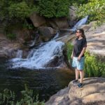
After lunch, we walked a bit further to a viewpoint, which affords some fantastic views of the surroundings. Then we retraced our steps and headed back to the car to continue our journey.

We somehow missed the dead-end path leading to a second viewpoint on a tower. Look out for it.
Info: To complete the remaining stretch of the official route, retrace your steps to the gate and, once you’ve passed through the gate, follow the path bearing left to the end of the one-way route. Then retrace your steps all the way back to the start point. I will expand this section once I’ve returned and completed the full route.
Practical info
When to do this route: winter and spring would be the best seasons for completing this route. End of winter will offer the greenest landscapes, but spring (end of March-May) is when the rare wild peonies (paeonia broteri) bloom, so it may be hard to choose. I walked part of this route in mid-December. Now I want to go back in spring to do the full route. I will update this article when I do.
Where to park: there’s no designated parking area near the start point of the route. Don’t make the same mistake we made by getting onto the unpaved road with the car – it’s meant to be used by locals accessing their farms, there are fences on both sides of the road, and turning around can prove tricky.
Parking in the area outside the nearby cemetery is prohibited, since it’s meant for use by people visiting the cemetery. Please do not park there.
What to do instead: drive to San Jorge de Alor, find some free on-street parking and walk to the start point.
Walking to the start point: there’s pavement on the right side of the main road from San Jorge de Alor to the zebra crossing at the cemetery. The pavement then turns into a cycle path (with shared used by cyclists and pedestrians). Walk on the cycle path and then cross the main road onto the unpaved road. The walk from the end of the village to the start point of the route takes about ten minutes.


More ideas of what to see and do in the Olivenza area:
This content is protected by copyright and belongs exclusively to Irene Corchado Resmella. To know exactly what this means, read the 'Copyright' section in the Website terms of use.
Irene Corchado Resmella
Hi! I’m Irene (/ee-REH-neh/). Long since settled in the UK, I explore my Spanish home region of Extremadura with an inquisitive mind, a sharp eye, and the duality that comes with being both a local and a visitor. Then I write about it here to help you discover this beautiful yet overlooked part of Spain. If you have any questions after reading this article, submit a comment below! Read more about me.