(Last updated on 13/10/2025)
Cerro de Masatrigo is a peculiar hill situated in La Siberia area of Badajoz province. Surrounded by the waters of La Serena reservoir, this almost-conical island-looking hill, popularly known as the ‘Magic Mountain’, rewards walkers with some spectacular panoramic views from the top.
In this article, I share a general overview of the route (Senda de Masatrigo), some practical info, thoughts, and personal tips to help you plan your walk up one of Extremadura’s most unusual places.

Table of contents
Overview
Cerro Masatrigo, declared a Natural Monument in May 2023, is located near the outlying village of Galizuela (belonging to the municipality of Esparragosa de Lares), within a Special Protection Area for birds. Senda de Masatrigo is a local (SL) FEXME-approved three-in-one route of 4.6 kilometres in total.
There are three options available for walking in Cerro Masatrigo:
1. Route A: a circular low-effort 2.4-km route around the middle of the slope.
2. Route B: a linear high-effort 2.2-km route (1.1-km one way) to the top of the hill.
3. Completing Route A, followed by Route B

This article covers Route B only, which is the one I have (so far) completed myself.
Start: lat. 38.93604, long. -5.21167
Finish: lat. 38.93388, long. -5.20839
Length: 2.2km (1.1km each way)
Time: 50-60min in total
Difficulty: medium (3/5)
Senda Masatrigo (Route B) on a map
(Please note that I manually drew the route and it’s meant for rough reference only.)
My thoughts on walking Route B
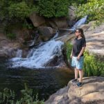
I walked Senda de Masatrigo (Route B) in mid-September and, as you will probably tell from the pictures, it was hot. We started walking at around 9.40am and by 10am I already found it too hot. There are barely any shady spots to stop on the way up. Being constantly exposed to the sun made me inadvertently walk a bit faster than I’d normally would and that made me tired quite early on. This was a good reminder that summers in Extremadura are not good for walking.
Route B is short (1.1km one way) but very steep and hard on your calves, with a cumulative elevation gain of 106 metres. Amongst the (at the time) very dry very yellow vegetation, dotted with pine trees here and there, there’s a signposted example of an Iberian pear tree. Known in Spanish as piruétano, the Iberian pear tree (Pyrus bourgaeana) bears small round and incredibly rough pears which are inedible for human consumption, although some wild animals eat them.


On the second half of the ascent you reach a rocky area with great views to the north and northwest. It’s a good spot to stop briefly before tackling the final stretch to the top.

The viewpoint at the top of Cerro Masatrigo offers a 360-degree view of the surrounding area. The EX-322 road bridge to the south far below puts the elevation gain into perspective. Had I done this route at a different time of the year, I’d have taken a picnic with me and spent a bit more time enjoying the incredible views. Even so, I found the (at the time) almost desertic-looking landscapes nothing short of extraordinary. Now I look forward to going back in winter or early spring to enjoy different natural colours.

Tips and practical info
When to do this route: Senda de Masatrigo is recommended for a dry and clear winter or early spring day. Temperatures will be mild enough, the water levels in the reservoir will be high and the landscape will look its best, nice and green after some late autumn and winter rain.
Before the walk: Cerro Masatrigo is essentially a giant roundabout on the EX-322 road. This single carriageway becomes a single-track road at the roundabout, where you can only drive in an anti-clockwise direction. Drive around the roundabout to get a sense of the surroundings at ground level and of the hill you’re about to climb.
Where to park: there’s a free parking area just off the road, on the northern side of the hill. Coordinates: lat. 38.937462, long. -5.210236. Google Maps shows other ‘parking’ areas around the hill but please note they are lay-bys, more suitable for a quick stop than for parking.
Start point: bear in mind that the start point of this route is some 55-60 metres away from the parking area and you need to cover that distance on foot walking on the single-track road in the same direction as cars. Traffic is usually inexistent, but walk briskly and use caution when crossing the road.
Photo spot: there’s a good spot for taking a picture of Cerro Masatrigo to the south of the hill, on the other side of the bridge. Park your car (lat. 38.923905, long. -5.207096) and walk a bit down the path until you find your preferred angle.
Idea: For a walking route with views of Cerro Masatrigo, check out Sendero Fortaleza de Lares.
This content is protected by copyright and belongs exclusively to Irene Corchado Resmella. To know exactly what this means, read the 'Copyright' section in the Website terms of use.
Irene Corchado Resmella
Hi! I’m Irene (/ee-REH-neh/). Long since settled in the UK, I explore my Spanish home region of Extremadura with an inquisitive mind, a sharp eye, and the duality that comes with being both a local and a visitor. Then I write about it here to help you discover this beautiful yet overlooked part of Spain. If you have any questions after reading this article, submit a comment below! Read more about me.